Cherokee Outlet
ENID, OK - The Federal Government had granted seven million acres of land to the Cherokee Nation in treaties of 1828 and 1835. The United States guaranteed to the Cherokee Nation that this land would be a perpetual outlet west for tribal hunting grounds, measured 58 miles wide and extending 220 miles along the northern border.
After the Civil War, because part of the Cherokee Nation had supported and fought for the Confederacy, the federal government demanded that a new treaty be written. The new treaty reduced the original reservation lands and permitted "friendly tribes" to be moved into the eastern end of the Outlet.
With the start of the cattle drives following the Civil War the Cherokee Indians began to use their western land to make a money. The Cherokee leased the land to the cattlemen that wanted to fatten their cattle on the grasses before taking them to Kansas. This eventually became the Chisholm Trail.
The trail reached Enid from south on the west side of where the Rock Island tracks run, broadening out and swerving somewhat eastward. It followed Grand Ave., past the old Gensman corner (across the street southeast of the library), on north where the Alton Building (Leonardo's) was, to the Skeleton Stage Station where the Enid State School was, and north to the trail's end in Kansas.
Mail routes and stage coaches followed the Chisholm Trail. The first mail route was between Wichita and Ft. Sill, Indian Territory. Four stations for change of horses, rest and food were in the Strip, two of them in Garfield County - at Skeleton Station and at Buffalo Springs.
All of Garfield County was covered with ranches during the era of the cattlemen, but only a few dim traces of that colorful period remain today.
Opened by "land run" on September 16, 1893
Settlers, wanting to own their own land, viewed this use of the area as a waste of fertile farmland and pressured the government to purchase the land from the Cherokee. Congress eventually paid the $8,505,736 or about $1.40 per acre, and announced the opening of the Outlet to homesteaders.
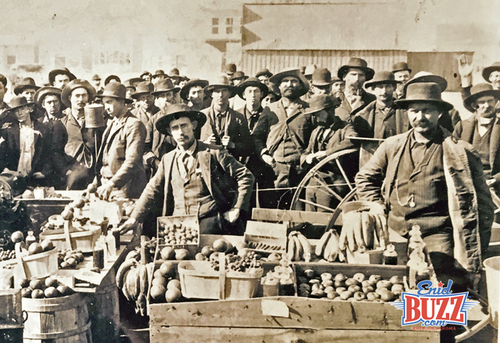
President Grover Cleveland designated September 16, 1893 as the date of the "run" for 6,000,000 acres. On that day, 100,000 land hungry persons gathered for the land run into the Cherokee Outlet by horse, train, wagon and even on foot. From Caldwell, Kansas 15,000 people gathered to make "the Run" south into what is now Oklahoma. Caldwell was 1 of 9 places where potential settlers awaited cavalry soldiers' gunshots to start the biggest land rush in the United States.
How Enid Got Its Name
Before the land run, the Rock Island trains had been stopping at what is now North Enid. They had a depot there and the railroad had named the town Enid. There has long been several versions of how Enid got its name, but clearly the most recognized and plausible theory was that Enid was named by M. A. Low who was a vice-president and general counsel for Rock Island.
In the early 1930s, George Rainey, who was one of the preeminent historians on the Cherokee Strip, in researching his book on the Cherokee Strip traced down several versions on how Enid got its name. He came to the clear conclusion that it was Low who named the station as an alternative to the its initial name Skeleton Station. Low felt that no town would ever want the name Skeleton. He had been reading Lord Tennyson's Idylls of the King on the railroad trip from Kansas. Enid was a prominent character in Tennyson's book. She was the second most fair lady of the realm, second only to Guinevere. It is believed that Low named Enid after that character.
Becoming Cities
At the end of the run, farms were quickly being established, and the cities of Enid, Perry, Alva, and Woodward had been formed out of what had been only prairie land and train depots the day before.
The original train depot, before the run, was located in North Enid. Soon after the run, a second Enid town site was plotted south of the original one. In the beginning, the railroad refused to stop at the south township which caused a struggle between the two towns that were only three miles apart. The feud was eventually resolved through some unsavory tactics and the south Enid began to receive train service. Because a post office had already been established in the south town called Enid, a post office later built in the north town had to be designated North Enid.
7 Original Counties
At the time of the 1893 Land Run, there were 7 original counties called: O, L, K, P, Q, M and N. "O" County was provided with a county seat reserve of 320 acres, a plot of four acres for a court house, and one acre for a government land office. The county seat was Enid, and eventually "O" County became Garfield County. The settlers of each county were given the right to select the name of their county after the run. The names selected were Garfield, Grant, Kay, Noble, Pawnee, Woods and Woodward.
The first Methodist circuit rider to arrive in Enid was the Reverend O.R. Bryant. This courageous young minister preached to a small congregation of early settlers on Sunday, September 17, 1893, the day after the great run into the Cherokee Strip. The service was held on the courthouse lawn and was the first Protestant sermon delivered in Enid. This was the beginning of the First Methodist Church in Enid.
Through all the hardships of life on the prairie, including the Dust Bowl, Enid became the center of commerce for all of Northwest Oklahoma. Enid was the center for farming, cattle, oil and industry and even had an automobile called the Geronimo was once manufactured here.
Learn more Facts About Enid, OK HERE.
National Register of Historic Places in Enid, OK
Did you know there are 15 National Register of Historic Places Sites located within the City of Enid? The US Department of Interior recognizes these sites as being historically significant to our city, state, and Nation. The sites include:
1. Broadway Tower (114 E Broadway)
2. H.H. Champlin House (612 S Tyler)
3. T. T. Eason Mansion (1305 W Broadway)
4. Enid Armory; demolished to make way for Garfield Elementary (6th & Elm)
5. Enid Cemetery & Calvary Catholic Cemetery (200 Block of W Willow)
6. Enid Downtown Historic District
7. Enid Terminal Grain Elevators Historic District
8. Garfield County Courthouse (West Broadway)
9. Jackson School (415 E Illinois)
10. Kenwood Historic District
11. Lamerton House (1420 W Indian Dr)
12. McCristy-Knox Mansion (1323 W Broadway)
13. Rock Island Depot (200 Owen K. Garriott Rd)
14. Waverley Historic District
(Historic Roadside Marker located in 1300 block W Broadway)
15. H. L. Kaufman House is listed; however, home was demolished in 2005 by the Enid Public School System to make way for an expanded playground at McKinley School